


Weather Radar for Central Macedonia

Central Macedonia and Thessaly Radars (merged result)

Updates every 15 minutes
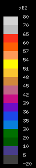
Scale of dBZ values
 |
|
||||||||||||||||||||||||||||||||||||||||||||||||||||||||||||
dBZ stands for decibels of Z. It is a meteorological measure of equivalent reflectivity (Z) of a radar signal reflected off a remote object. The reference level for Z, is related to the number of drops per unit volume and the sixth power of drop diameter.
Reflectivity of a cloud is dependent on the number and type of hydrometeors, which includes rain, snow, and hail, and the hydrometeors size. A large number of small hydrometeors will reflect the same as one large hydrometeor. The signal returned to the radar will be equivalent in both situations, so a group of small hydrometeors is virtually indistinguishable from one large hydrometeor on the resulting radar image.
A meteorologist can determine the difference between one large hydrometeor and a group of small hydrometeors as well as the type of hydrometeor through knowledge of local weather condition contexts.
Despite the detailed scale above, a more "realistic" approach of rain rate is as follows:
0-8 dBZ Barely anything |
8-23 dBZ Light |
24-39 dBZ Moderate |
40+ dBZ Heavy+ |
© SOURCE: http://www.3dsa.gr/

Timestamp is UTC/GMT (GR: +2 hours at winter time (November->March), +3 hours at summer time (April->Oct)